
 Tekmap Consulting uses custom built software for 3-D data visualization and animation. The custom visualization software, developed by Tekmap Consulting, uses the Open Source GRASS OGSF library and the NASA World Wind Software Development Kit (SDK).
For examples of our data visualization and animation products, please visit the Movie Gallery or check out our YouTube Channel.
GRASS Based Viewer
The 3-D data viewer developed with the GRASS OGSF library provides:
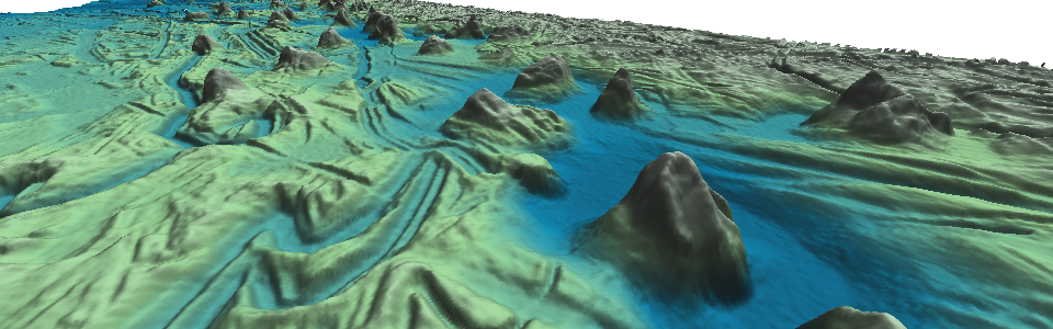
- Multiple surface visualization.
- GRASS feature overlays (e.g. vectors).
- Cutting plane visualization.
- Surface transparency.
- Custom scalebar.
- Custom raster colorbar.
- Text overlays.
- 2-D location map inset.
- Annotated cutting plane (profile).


NASA World Wind Based Viewer
The 3-D data viewer developed with the World Wind SDK provides:
- Global data perspective.
- Data tiling for large or multiple datasets.
- Fusion of high resolution digital elevation model with background World Wind data.
- Timed Keyframe animation.
-
Custom overlays including:
- KeyMarkup Files (KML/KMZ).
- Vector / Point / Image overlays.
- 3-D COLLADA models.
- Airspace models.
- Platform independent.
Client specific overlays or features (such as logos, positions, etc) are available upon request.
Final Products
A number of 3-D visualization output products are available.
| Product | Description |
|---|---|
| Custom Fly-Through Animations | A fly-through movie created at full resolution along a user defined route or highlighting a user defined feature. Can include above annotations. Available in High Definition (HD) in a variety of formats. |
| 3-D Still Shots | 3-D views saved to image format with supported overlays. High resolution (poster size) is available. |
| Multiple Surface Visualization | 3-D visualization and animation of multiple surfaces. This is useful for visualizing the difference between repeat surveys. Can also be used to add artificial surfaces such as a water layer to multibeam data. |
| Cutting Plane Visualization | Visualization of 2 or more surfaces with a cutting plane, or profile cutting through the surfaces. Provides excellent cut-away views of data in 3-D. Tekmap uses this feature to fly along ice scours while keeping the cutting plane at the center of view. This provides valuable information on changing surface morphology. |
To obtain an estimate or for more information on our Data Visualization & Animation Services, please contact us.